Here
is a statement from the Scientific Visualization Studio of the NASA Goddard
Space Flight Center on Radarsat mapping over Antartica: http://svs.gsfc.nasa.gov/imagewall/antarctica.html
Note that dark areas are attributed to poor reflectivity which can be due to
smooth ice:
" Unlike traditional photographs from space, a dark area does not
necessarily mean that less light is falling on the surface; as translated by
radar, dark does not mean shadow. Instead, light and dark are relative
measurements of radar reflectivity. Finely powdered snow and smooth ice with few
imperfections both tend not to scatter radar projected against it; hence they
look dark. Coarse material like old, pitted ice, rock slides, and crevasses
scatter the radar beam and thus look bright--a strong radar
signal." ( From Science Magazine )
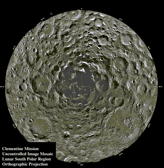
On July 31, 1999, the space probe Lunar prospector was directed to intentionally
crash into the Crater Malapert
(above), at the South Pole of the Moon. The idea was that
the poor reflectivity of this deep crater, as perceived by the earlier
Clementine probe, suggested the existence of ice, since Malapert is deep and
never receives direct sunlight, and NASA wanted to see if the crash would induce
a tell-tale water vapor cloud.
"Composite Clementine orbital images of the poles of the moon, where more
than 50 separate images have been summed together over one lunar day. In these
views, areas of near permanent illumination are white and areas of near
permanent darkness are black. Within 100 km of each pole, the south pole (B)
shows considerable darkness (= cold traps) whereas the immediate surroundings of
the north pole (A) show at least an order of magnitude greater illumination, and
are therefore warmer." ( IBID )
What if the less-scattered radar signal, only suggesting ice, was due to the fact
that Malapert is the Southern Polar orifice? Perhaps radiations emanating from
the orifice at the South Pole of the Moon, apparently located in Malapert, plays
havoc with radar signals and falsely gives the impression of ice.

The image above is from the Lunar Reconnaissance Orbiter, or LRO. It was culled from the October 21, 2010 edition of the NASA Science News publication by Lonni Clarke of Saint George, Utah. The dark blotch close to the intersection of the crosshairs is just above Malapert at the lunar South Pole. Since it has been blotched out, it could very well be where the opening is. Hats off to Lonni Clarke, I'd say she found it!
Even more recently (April 2011), "lightofmilkyway," of the allplanets-hollow List on Yahoo!Groups, culled the image below from the Diviner Lunar Radiometer Experiment project at UCLA. The opening seems to be the dark area at the upper right from the crosshair intersection; the darkness, of course, indicates that there is depth. As follows there is a broad view of the Diviner Lunar Radiometer Experiment project:

Further Pages of Interest: